

EKKO_PROJECT SOFTWARE
EKKO_Project Software options for the LMX150 & LMX200 GPR
By Radiodetection!
Multiple Configurations Available
This product is configured specifically to suit your needs.
Request Configuration Assistance
Contact us to discuss your requirements
EXCLUSIVE Australian Industry BEST PRICING available.
EKKO_Project GPR Software
LINK
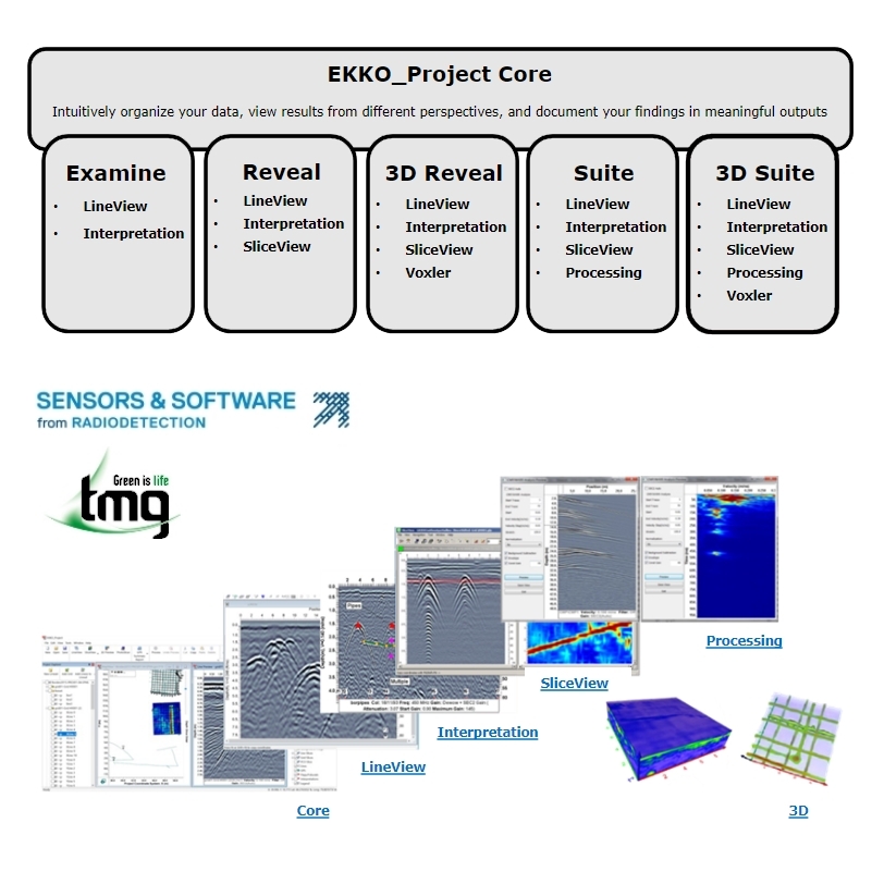
Radiodetection's EKKO_Project Software Suite
Radiodetection's Sensors and Software GPR units are designed for locating and mapping subsurface utilities, structures, and anomalies. The EKKO_Project software suite provides the tools for processing, analysing, and visualizing the data collected by the GPR units. Here's a brief explanation of each software within EKKO_Project: The 6 software options below are designed for the Sensors and Software "LMX150 Findar" and the "LMX200" GPR units.
CORE
The CORE software is the primary software application used for controlling the GPR unit and collecting data. It provides users with an interface for setting up the GPR unit, defining data acquisition parameters, and managing data files. The software also includes basic processing functions like filtering, gain control, and time-zero adjustment, which allow users to pre-process the data before further analysis. Additionally, the CORE software allows users to export the data to other software for more advanced processing.
EXAMINE
The EXAMINE software is an advanced processing and analysis tool for GPR data. It includes features like velocity analysis, waveform inversion, and migration processing, which allow users to extract more detailed information from the data. Velocity analysis helps users estimate the velocity of electromagnetic waves in the subsurface, which is crucial for determining the depth of subsurface features. Waveform inversion allows users to extract information about subsurface properties, such as conductivity and dielectric permittivity, by fitting the data to a model. Migration processing allows users to create more accurate images of subsurface features by compensating for the uneven distribution of energy in the GPR data.
REVEAL
The REVEAL software is a visualization tool for creating 2D maps of GPR data. It allows users to create maps of the subsurface that show the depth and location of subsurface features and anomalies. The software includes features like automatic depth slicing and colour mapping to help users visualize the data and identify subsurface features. Additionally, REVEAL allows users to import and overlay other data types, such as GPS data or utility maps, onto the GPR data, which helps with mapping and analysis.
3D REVEAL
The 3D REVEAL software provides similar visualization functions as REVEAL but in a 3D format. Users can view and manipulate the GPR data in a 3D environment, which allows for a better understanding of subsurface structures and anomalies. 3D REVEAL allows users to create detailed 3D models of the subsurface, which can be rotated and zoomed to view from different angles. Additionally, 3D REVEAL includes tools for visualizing and analysing data in a volumetric format, which provides a more complete view of subsurface features.
SUITE
The SUITE software package includes both CORE and REVEAL software, providing a complete solution for basic GPR data collection, processing, and visualization. Users can use the CORE software to collect GPR data and then import it into the REVEAL software for basic visualization and mapping. The SUITE software is useful for users who need a complete solution for basic GPR data analysis and interpretation.
3D SUITE
The 3D SUITE software package includes both CORE and 3D REVEAL software, providing a complete solution for advanced GPR data collection, processing, and 3D visualization. Users can use the CORE software to collect GPR data and then import it into the 3D REVEAL software for advanced 3D visualization and analysis. The 3D SUITE software is useful for users who need a complete solution for advanced GPR data interpretation and analysis, such as geophysicists or geologists.
EKKO_Project GPR Software
Why should you use EKKO_Project?
- Ekko_Project helps to streamline project workflow and increase data processing efficiency.
- A variety of outputs depending on your clients needs.
- Easily archive all work performed, including photos, for insurance purposes.
- Provide higher quality service to your customers.
- Generate additional revenue from selling reports/outputs to clients.
- Differentiate your service by delivering outputs that your competitors do not.
- Set data delivery standards that your competitors cannot match.
- The cost of software usually pays for itself in a short time.
(EKKO-OPTIONS)
Available Downloads
Brochure

| SKU | EKKO-OPTIONS |
| Model # | EKKO_PROJECT SOFTWARE |
| Brand | Sensors and Software |
0
Be The First To Review This Product!
Help other Contractor Essentials users shop smarter by writing reviews for products you have purchased.
More From This Category


Your Browsing History


